The Bridge Blog
A dialog about our new bridge and these web pages
Overview. As a pointy-headed
university professor, my weekend project of bridge photography and
building these web pages generated many questions and introduced me
to just-in-time learning. I enjoy chasing my curiosity and
want to identify ways to encourage younger learners to also enjoy curiosity
chasing and learning.
Learning usually requires repetition while forgetting occurs when
I infrequently use information. Many young learners do not understand
the importance of repetition. Weekly visits to the bridge provided
the repetition necessary to detect changes in the bridge and
consequently generated
many questions and opportunities for learning. Over the course of the
bridge project, I had access to few experts for answering questions.
Rather than a liability, this became an asset and pushed me to improve
my search skills with Google. Soon, I found that answers
to questions encountered during my weekly photo shoots were often
only a Google-search away -
(see
Restoring the Joy in Learning). Consequently Google + Internet became
dependable extensions of my memory.
The bridge story is a work in progress and is evolving from a simple
collections of photographs to an experiment with Internet-centric
just-in-time learning.
Insights I gain from you
will find their way into the learning centers of MUSC.
Palmetto Bridge Constructors, a joint venture between
Tidewater
Skanska and
Flatiron Constructors, as well as
High Steel Structures,
Freyssinet, the
SCDOT and the
Federal Highway Commission Office
of Bridge Technology guided much of my learning.
I also learn from many of you and from Google-linked resources. More
important is the e-mail encouragement I receive from many of you.
Fri, 01 Apr 2005
April 1, 2005: A new project
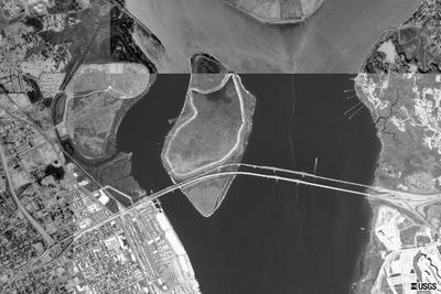 Tim Linder has a great idea. What about collecting aerial and satellite
images acquired during the construction of the new Cooper River Bridge.
We found this image from the US Geological Survey (1999).
In addition, the
US Geological Survey has a very useful image browser. This link includes
southern South Carolina.
Terraserver.com has a more
recent (October 13, 2003) photo from GlobeXplorer at coordinates:
Latitude: 32.8070077 , Longitude: -79.927839 .
Tim Linder has a great idea. What about collecting aerial and satellite
images acquired during the construction of the new Cooper River Bridge.
We found this image from the US Geological Survey (1999).
In addition, the
US Geological Survey has a very useful image browser. This link includes
southern South Carolina.
Terraserver.com has a more
recent (October 13, 2003) photo from GlobeXplorer at coordinates:
Latitude: 32.8070077 , Longitude: -79.927839 .
Terraserver (support@terraserver.com) readily gave me permission to use their 2 meter
(Oct 13, 2003)
resolution image of the construction site. In addition, I found imagery at
NASA's Gateway to Astronaut Photogrphay of
Earth.
I have sent email to
Spot Image in France, another source of satellite imagery.
My experience is that "front" doors
sometimes don't work as well as some "back" doors. So if any of you have some back door
contacts with satellite imagery groups -
send me
email with your information. I shall build a new page
of
satellite imagery with what we are able to locate. Thanks
posted at: 23:55 | path: | permanent link to this entry

